National Parks Journal, DECEMBER 1998, pages 6 to 12
Serengeti shall not die - National parks in Tanzania EJ Gereta*
Tanzania National Parks (TANAPA) is a parastatal organisation formed under the Ministry of Natural Resources and Tourism, formed by the National Parks Ordinance of 1959. The ordinance provides for the establishment, control and management of national parks in Tanzania. Tanzanian national parks, within the context of this ordinance, are areas of natural wilderness from which permanent human settlement and consumptive utilisation of resources by humans is prohibited.
The areas so gazetted as national parks are intended to conserve the scenery, the habitat, the flora and fauna therein and to promote and provide for the enjoyment of future generations (Serengeti National Park Management Plan, 1991-1995). TANAPA has the mandate to hold in trust all national parks in the country. Tanzania has 12 national parks and nearly all of them are terrestrial, with the exception of Rubondo Island NP which is in Lake Victoria. At the moment TANAPA does not have a marine park, although efforts are under way to establish some.
Land tenure Understanding Tanzania's land tenure system is essential to the context for the degree of commitment to protecting and conserving wildlife. At post-independence, the government legislated tenure reforms which were based primarily on colonial policy and statutes: all land and natural resources are publicly owned and are under the control of the State; land rights and title are based on use and occupation, not ownership; forbidding land speculation and commoditisation; rights of occupancy (whether granted or deemed) as the only recognised tenure (Kerario, 1998).
Thus the Tanzania Government is allowed to have the final decision on the protection and conservation of wildlife. Based on this tenure system, TANAPA holds in trust 12 national parks occupying about 4.37% of the total land area.
Apart from national parks, the country has game reserves, game controlled areas and forestry re serves. All of these form protected areas with a total land mass of about 26%. This is the highest percentage reached by any coun try at the moment. The country's commitment to conserving wildlife has been expressed in the Arusha Manifesto by the former President Mwalimu Julius K Nyerere in Sep tember 1961 which states: "The survival of our wildlife is a matter of grave concern to all of us in Africa. These wild creatures amid the wild places they inhabit are not only important as a source of wonder and inspiration but an integral part of our natural re sources ...
"The conservation of wildlife and wild places calls for specialist knowledge, trained manpower, and money, and we look to other nations to cooperate with us in this important task, the success or failure of which not only affects the continent of Africa but the rest of the world as well." Park systems The park system can be divided into three major categories: Savannah parks: these are comprised of grass lands associated with woodlands. Some areas are open grasslands and others are wooded grasslands. The type of woodlands differs those in the south con sist of miombo wood lands, whereas those in the north contain aca cias. The largest park in this category, and in deed in Tanzania, is Serengeti NP, with 14,763 km 2 . Other savannah parks are Tarangire, Ruaha, Mikumi and Katavi national parks. Mountain parks: there are four of these parks. They are covered with forests and also comprise mountains. Udzungwa Park belongs to the Eastern Arch Mountains whereas Arusha has Mount Meru, second highest mountain in the country; Kiliman jaro NP contains Mount Kiliman jaro, the highest mountain not only in the country but in Africa. Mahale, on the other hand, com prises the mountain and part of Lake Tanganyika. Aquatic/wetland parks: these are parks which have an inland lake, such as Lake Manyara NP; or is an island, such as Rubondo Island NP; or the park has a portion of Lake Tanganyika, such as Gombe NP (the smallest national park, with 52 km 2 ). Under Ramsar these parks would qualify as wetlands but the Tanzanian Government has not signed the convention. These parks have many streams and rivers. Mahale too forms part of the aquatic system. Lake Manyara Park has more than half of its area covered with the lake, along with ground water forest.
Park management For a long time park management had no definite plans which could be used in carrying out park activi ties. In 1990 the TANAPA Park Planning Unit was established with the assistance of IUCN (now the World Union for Conservation of Nature). The aim of establishing the unit was to facilitate the maintenance of pristine park conditions which would take better care of environment protec tion and conservation, so that visitors could enjoy wild nature with very minimal destruc tion. Since some parks have high visitor de mand, development of various infrastructures needs to be properly organised and located to maintain true nature of an area. The plan ning process led to two types of plans: general manage ment plan, which incorporates environmental impact assessment (GMP/EIA); and management zone plan with environmental impact assessment (MZP/EIA). GMP/EIA: This plan gives detailed prescription of various actions to be carried out in the park including budgeting. EIA takes care of over development and proper develop ment without destroying the envi ronment. This plan takes a long time to prepare because of the inputs required - generally over two years from its preparation to approval by the Board of Trustees. MZP/EIA: This takes a shorter time to prepare. This type was intro duced to cater for the pressure exerted by developers of tourism facilities. To catch up with the kind of development needed, a MZP/EIA has to be prepared before a GMP/ EIA. The plan takes about eight months to prepare and be ap proved by the Board of Trustees. The plan does not give detailed prescription of activities and does not provide for budgeting.
Since these plans are still new, not all parks have them, although efforts are being made to make sure that every park has a plan, whether MZP/EIA or GMP/EIA.
Different parks have had differ ent emphases on their manage ment, for instance: Serengeti NP is one of the most studied ecosystems in the world. Major concentration has been on major mammals and wildebeest migration. Despite this study, the park still has some limitations in cluding lack of or no information on fish, insects, reptiles and amphib ians and water studies.
Rubondo NP is an island park. Although it is surrounded by water, not much aquatic work has been done, and most management of the park is concentrated on terrestrial ecology. Translocation of chimpan zees, elephants, rhinos and giraffes was carried out, although rhinos have not been sighted for a long time. Abnormal deaths of sitatunga (present only in this park) and bushbuck for the last two years also call for a detailed study.
Mikumi NP: the emphasis here has been the study of yellow ba boons' behaviour. Some work on elephants has just begun.
Arusha NP: some work on utilisa tion of forest glades by large mam mals was done in the past. At the moment most of the work on animals is done by inter national students, espe cially from the USA.
Kilimanjaro NP needs its inventory taken so that some studies can be planned and carried out. There is potential for working on both terres trial and aquatic ecol ogy.
Gombe NP: most work has focused on chimpanzee behaviour and conservation.
Mahale NP shares a part of Congo forest and has chimpanzees too.
Udzungwa NP be longs to the Eastern Arch Mountains. It contains most of the endemic species of flora and fauna; because of this richness of biodiversity, many researchers are Successful management in Serengeti NP Photos: Eric Wolanski GRAPHIC - SEE LASER PRINT SUPPLIED. FILE SUPPLIED ON DISK JPEG & GIF. NEEDS CROP PING TO SAME SIZE AS LASER PRINT. 8 DECEMBER 1998 attracted to this park.
Ruaha NP: major work here has been the study and conservation of elephants.
Lake Manyara NP: although the emphais in the past has been the conservation and protection of elephants, Manyara Park is faced with a major threat from human population. The park is surrounded by villages and developments, making it difficult for animals to have a sufficient dispersal area.
Tarangire NP: all animals here go outside the park in the wet season to Simanjiro Plains and most of the calving takes place there. During the dry season all the animals return to the park.
Local communities live within animal dispersal areas. These communities are developing the areas, as well as establishing large-scale farming along with livestock keeping and hunting. These activities are creating problems for animal security and decreasing dispersal areas. The government has been seeking remedial measures, including a policy of establishing wildlife management areas (WMAs) which is already approved by the government. WMAs are important areas used by wildlife for dispersal or as migratory corridors. To assist understanding of the value and importance of these wild animals, the government has decided to empower the people in proper management of these areas.
This allows people to have control over hunting and anti-poaching activities. The areas are also used for tourism activities. The benefits accrued from such activities are to be used to raise the economic well-being of the communities. Further assistance comes through TANAPA with community conservation services these offer training on anti-poaching, tourism operations and general management so that proper conservation principles are applied and implemented for sustainable development. The parks now working on such programs include Tarangire, Manyara and Ruaha.
Park research Research in Tanzanian national parks is allowed and encouraged. Both academic and managementoriented research are accepted, although the latter is preferred since research is an essential tool in the park planning process. Under the park set-up most ecological work focuses on monitoring. Research is generally carried out by personnel from outside TANAPA under the auspices of the Serengeti Wildlife Research Institute (SWRI). SWRI is the sole government body empowered to oversee all wildlife research.
Park administration Park administration is run by the wardens, most of whom have had general wildlife management training. There are also major players in the administration from other disciplines such as ecologists, veterinarians and so on.
The administration of each park is headed by the Chief Park Warden or Principal Park Warden, under whom is the deputy. There are various departments, such as anti-poaching, tourism, community conservation service, accounts, ecology and veterinary services. There are parks which lack some departments, such as ecology. Efforts are under way to make sure all parks have ecologists and that each has a veterinary team.
Conclusion Tanzania National Parks has the mandate of: "managing and regulating the use of areas designated as national parks by such means and measures to preserve the country's heritage, encompassing natural and cultural resources, both tangible and intangible resource values, including the flora and fauna, wildlife habitat, natural processes, wilderness quality, and scenery therein and to provide for human benefit and enjoyment of the same in such manner and by such means as will leave them unimpaired for future generations." (TANAPA Policy, 1994) Acknowledgments I acknowledge the assistance of the Director General, Tanzania National Parks, for allowing this paper to be published; the Chief Park Warden, Serengeti National Park, Mr Lota Melamari; and the senior staff of Serengeti National Park for cooperation during the preparation of this paper.
References
* Dr Emmanuel J Gereta is Senior Park Ecologist at Serengeti National Park, Tanzania.
PHOTO NO 3 CROP AS MARKED & EXPAND BY 25% Giraffe in Kruger NP, South Africa Photo: Leigh Wood/Geoff Smith
ARTWORK NO 1 REDUCE BY 55% National parks in Tanzania DECEMBER 1998 7
DECEMBER 1998 p9
Environment News & Action
Lake Cowal Inquiry
Is the gold that lies beneath Lake Cowal sufficiently important
that the area should be forever compromised?
Norths, the major resource conglomerate, had their previous application for a large open-cut mine intruding into the lake refused two years ago. Many will remember Premier Carr's commitment to the dying Milo Dunphy that the mine would not be approved. Sheila Smith (in her June 1996 Journal article) warned that this was unlikely to be the end of the story.
Norths have addressed a number of the concerns in a new EIS with a second Development Application now at the Commission of Inquiry stage. Norths also pioneered new ground with negotiation of a Memorandum of Understanding with leading NSW environment groups (NPA along with TEC, NCC and SAFE - Save Animals From Extinction). The MOU does not support the mine, but provides for a non-profit Trust to work toward long-term conservation initiatives should the mine get the go ahead.
Lake Cowal, lying within the geologically mineralised Lachlan fold belt, is a large shallow, freshwater, ephemeral wetland near West Wyalong. It fills via floodwaters in wet years from the Lachlan River. Still a functioning wetland, it is a major waterbird refuge and breeding area.
Some locals in the region seem convinced the venture will give a much needed boost to the local economy, while promises of best practice may help to offset long-term salinity threats to the lake. Huge risks remain, not least contamination of aquifers and the lake over the long term, along with the legacy of a 325 metre deep void. Are we facing the best deal that can be achieved in the circumstances?
Whatever the outcome, a better system for evaluating mining from cradle to grave and beyond is long overdue. In an ideal world, an opencut gold mine in this precious place should not have been contemplated in the first place.
Anne Reeves
NPA Vice-President
Snowy final report
Six months ago the Snowy Water Inquiry was set up to look into
the effects of the Snowy Mountains Hydroelectric Authority on
river flows. It released its Final Report to the NSW Government
on 23 October.
While media attention has focused on the low flows in the Snowy River below Jindabyne Dam and outside Kosciusko NP, the Inquiry also looked at rivers inside KNP, including the upper Snowy River.
The Final Report recommends:
If the Report recommendations are adopted, flows at the mouth of the Snowy (at Orbost Reach) will increase to 60% of ANF. Over half the total inflows to the Snowy River are below Jindabyne Dam and are not affected by the Snowy Scheme.
The report has to be approved by the Victorian, NSW and Commonwealth governments, before the SMA is corporatised. No one is entirely happy with the Report, but it must not be watered down - it may be our last chance to restore some of the natural river flows in Kosciuszko National Park.
Bob Ross
Member
KNP - snow blind?
STOP PRESS - Perisher expansion decision
Commisioners Simpson and Train have ruled that the most significant use of the Kosciuszko National Park is for snow sports. Accordingly, they have proceeded to give the Perisher resort developers 1320 new beds rather than the 1066 first proposed. They have also paved the way for more and more development.
The Commissioners have shown a fundamental misunderstanding of the role and values of KNP. The park is an internationally important reserve for the conservation of nature and the protection of the massive Snowy River Hydro Scheme's water quality and quantity.
The Minister for Planning, Craig Knowles, should reject this report and call a halt to the growing cancer of urban development in one of the world's greatest national parks. The US Parks Service is spending millions of dollars just now to remove such commercial overdevelopment from American national parks.
And what sense does it make to expand ski resorts when the greenhouse effect, caused by global overdevelopment, threatens to destroy all our snow fields? The recent Thredbo tragedy makes clear the foolishness of urban development in treacherous alpine conditions. Don't we ever learn that greed is not good?
Noel Plumb
Executive Officer
News from the NPWS
$10 Million facelift for Sydney's Goat Island
Sydney Harbour National Park's Goat Island is to become a tourism centerpiece under a "master plan" for the historic site recently launched by Environment Minister Pam Allan.
The State Government, in partnership with private enterprise, will spend more than $10 million on a three-stage works program to create an accommodation and guesthouse facility; provide greater access to historic precincts; increase tours; and improve transport to the Island. The document titled A New Direction for Goat Island sets out the plan for the Island to become a major focus for Sydney by the 2000 Olympic Games, based on its prominent location within the harbour and its extensive natural and cultural attractions.
The plan was adopted after input from residents of nearby suburbs, tourism operators, environmentalists and other interest groups. The plan will also see the reactivation of the Goat Island slipway, now the largest operational slipway on Sydney Harbour. The massive winch used on it is believed to be the one involved in pulling the two halves of the Sydney Harbour Bridge together.
One of the key features of the plan is to provide greater access to the Island and its various precincts, thus enabling Sydney's visitors to learn and appreciate our Harbour's history.
Guided tours to the Island can be booked through the Sydney Harbour National Park Information Centre at Cadmans Cottage, 110 George St, The Rocks, Sydney 2000; ph 02 9247 5033.
Angela Burke
Media Assistant, NPWS
Eden forests disappointment
The Government's Eden forests decision is a disappointing and
unnecessary compromise rather than an historic decision to
resolve the long battle to protect the South East Forests from
woodchipping. NPA and most conservation groups have rejected the
decision. It is unacceptable as a long-term solution to the
conflict.
NPA welcomes the additional area of 37,000 hectares added to the reserves in the region, particularly additions to Biamanga NP and the South East Forests NP. However, it is extremely disappointing when compared with the government's own scientific assessment that some 82,000 ha should have been reserved, and the conservation movement's own reserve proposal of 57,000 ha, a substantial compromise in itself.
The Government has spurned the compromise peace proposal put forward with much anguish by the conservation movement in November last year and which was supported by 16,000 public submissions, some 79% of all submissions received on the assessment.
Although our proposal met the Government's stated minimum timber supply of 20,000 m 3 of sawlogs, the industry has been given 25,000 m 3 , another 25%, at the expense of old growth, wilderness and threatened species.
The decision: leaves significant areas of giant old growth to the woodchippers, including parts of the disputed Coolangubra Wilderness and key link areas on the escarpment of the Great Dividing Range; leaves more than a third of old growth forests in the region as State forest or private land - over 15,000 ha of this remains as State forest open to further clearfelling; leaves out any commitment to a defined low-impact logging zone of some 23,000 ha, proposed by conservationists to protect critical habitat for the regionally endangered koala population and other wildlife; leaves out any commitment to bring an end to clearfelling in the South East Forests, or to cessation of the export of woodchips which is driving the forest destruction; leaves more than half the identified Brogo Wilderness Extension (within Wadbilliga NP) outside the announced Brogo Wilderness, and continues to deny wilderness status to any part of the identified Coolangubra Wilderness.
Genuine environmentally responsible economic growth and jobs for timber industry workers lies with the region's extensive softwood plantations, which can supply the industry with ten times the sawlog resource promised by this disappointing decision. Timber workers have been cheated of their best prospects by their own union.
NPA and other groups are fighting to improve this outcome. Members should write to the Premier and ask him to review the decision.
Noel Plumb
Executive Officer
ARTWORK NO 2 REDUCE BY 50% DECEMBER 1998 p11
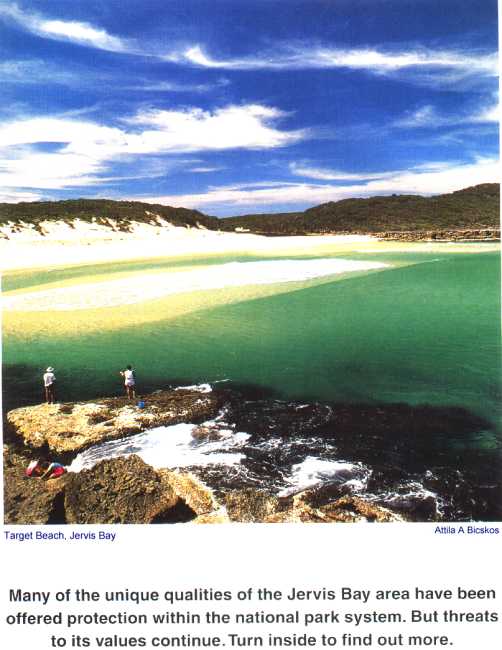
Jervis Bay wins and loses
Sally Gjedsted *
I n 1997 two NSW Government initiatives of particular relevance to the Jervis Bay Region were announced - the NSW Coastal Policy, by Urban Affairs and Planning Minister, Craig Knowles; and the Jervis Bay Marine Park by Environment Minister, Pam Allan. This was one of the first two marine parks to be declared in the State. The NSW Government has also made a commitment to the Jervis Bay Region in regard to purchasing private land for inclusion in the NSW park system, some of which is intended to provide a system of wildlife corridors.
There has been a major investment of public money in the region with the Government's commendable intention to maintain the natural values of the area, which depend upon the maintenance of the marine and terrestrial ecosystems.
The Coastal Policy seeks a sustainable future for the NSW coast but, as the Policy document states, the coast of NSW "is subject to management by a range of government and non-government organisations ... which can often be disparate and overlapping".
The Jervis Bay Region carries the baggage of second-generation ownership of large tracts of land purchased and subdivided by the "Imaginative Speculator", Henry Halloran, who dreamed of Pacific City, Jervis Bay City and St Vincent City some 80 years ago. That land is presently held by Warren Halloran and operated by Realty Realizations and associated companies.
The Jervis Bay Region is subject to Shoalhaven City Council's decisions which appear to be smoothing the way for large-scale developments.
The map accompanying this article (see over page) shows some of the proposals Shoalhaven City Council has been casting an approving eye on. These include the Heritage Estates; development at Lake Wollumboola; a resort at Huskisson; a subdivision at Vincentia Crossroads; and a bridge at Currambene Creek.
The Heritage Estates 1,100 lots in an old paper subdivision were advertised for sale in 1988 by Heritage Real Estate Pty Ltd. The advertised price was $4,950 for lots "zoned rural with no dwellings allowed". The land is now in individual ownership with the purchasers having formed a landowners' association to lobby local and State government for rezoning. In August, 1998, Shoalhaven City Council resolved to approve an option which would allow maximum development of the Estate. Areas within the Estate have been identified as land containing natural features of intrinsic value and sections of the system of wildlife corridors. A Local Environmental Study prepared for Shoalhaven City Council in 1994 concluded "that the development (of the Heritage Estates) would have a substantial and regressive impact on the locality in general."
A loan is being sought by Council from the NSW Government to provide infrastructure for this development.
Lake Wollumboola There is a proposal for a development of 3,000 dwellings on Realty Realization land within an area that includes the north-west catchment of the lake. The human impact of the proposed development, according to Coastal Council Chair, Prof Bruce Thom, "could have drastic effects on the whole ecosystem of the lake and its surrounds".
Lake Wollumboola is the largest mature shallow saline lagoon on the NSW South Coast and habitat for migratory and indigenous birds. The lake is listed under international treaties with China and Japan as a protected site for, at least, 24 species of migratory birds.
Resort development, Huskisson Hotel site A two-storey hotel on a headland site at Jervis Bay wins and losses Sally Gjedsted* Paradise Gardens, Bhewerre Peninsula Photo: Attila A Bicskos PHOTO NO 4 CROP & EXPAND BY 3 12 DECEMBER 1998 Huskisson has been approved for a resort development of 113 apartments, a tavern/bistro, restaurant, two shops and a conference centre. The approved resort design, from its northern aspect (that is, Currambene Creek and Jervis Bay), represents an effective six storeys of of residential accommodation. The 1997 Coastal Policy states the principle that "any development on headlands already developed should be strictly limited to height and scale no greater than existing buildings ..." An assessment of the visual characteristics of the locality and potential visual impacts of the development of the site commissioned by community members opposing this development states, in part, "In terms of its merit, I find hardly anything to recommend the visual qualities of the development. It is too tall, too bulky, too close to its boundaries, irrelevant to the forms and traditions of the town, insensitive to the heritage values of the hotel and the site, overpowering to the nearby reserves and the streetscape."
District Centre/residential subdivision, Vincentia Crossroads In 1970, Realty Realizations proposed a supermarket for a greenfields site adjacent to SEPP14 wetlands and national park. In the 1996 Local Environment Plan, which has yet to be gazetted, the supermarket proposal has expanded to an 11 hectare "business development zone" and an adjoining subdivision of 800 to 1,100 housing allotments. A major supermarket is due to open in 1999 in existing premises in the Vincentia Shopping Centre which is 1.7 kilometres from the proposed development site.
Currambene Creek Crossing bridge Shoalhaven City Council has engaged consultants to consider route options for a bridge proposal. While this would provide a road link between the northern and southern shores of Jervis Bay, it would also open up the prospect of a ribbon of development from Culburra to Callala, then Huskisson to Vincentia and on to St Georges Basin.
The 1997 NSW Coastal Policy states that, "ribbon development, unregulated cluster development, continuous urban areas and other inappropriate housing developments on the coast will be discouraged." Discouragement may not be enough for those "disparate and overlapping forces". In a 1992 Discussion Paper, "Our Heritage Our Future", prepared jointly by the NSW Department of Planning and Shoalhaven City Council, the Environment Protection Authority has assessed that "extensive urbanisation of the Jervis Bay catchment would readily degrade the waters of the Bay to an average rather than unique quality even with the adoption of the best practical stormwater pollution controls."
Conclusion This article has dealt with only some of the development proposals for the Jervis Bay Region. There are others, and other old paper subdivisions whose time has not yet come.
Meanwhile, Shoalhaven City Council, Keeper of the Gate to Jervis Bay, is proposing to "continue to lobby State members of Parliament to review fauna and flora legislation such that urban zoned areas are excluded" and "to ensure that all land zoned for a higher order use since 1985 should be excluded from this legislation".
Local groups have formed an Alliance to campaign against the many development proposals. They seek to protect and enhance the environment and the social and cultural heritage of the Region, and they need your help.
Write to your Local Member of Parliament; Premier Bob Carr; and Opposition Leader, Peter Collins; at Parliament House, Sydney NSW 2000, to express your concerns.
For further information, contact Sally Gjedsted on (02) 4441 5004. NPA also has a branch at Milton.
* Sally Gjedsted is Chair of the Jervis Bay Regional Alliance.
| NPANSW home page | Table of contents for this issue | Read on to the next page. |